Horizontal Coordinate System Explained — Altitude, Azimuth, and How They Differ from Equatorial Coords
The observer-based sky coordinate system (altitude + azimuth), how it differs from equatorial coordinates, conversion formulas, and practical uses — sunrise photography, telescope setup, satellite tracking, solar panels.
🌅 "The sun will rise at azimuth 90° this morning." — wait, what does that mean? The horizontal coordinate system is how you describe where something in the sky is, from your point of view on Earth. Two angles: how high above the horizon (altitude) and how far around from north (azimuth). It's what your phone's stargazing app uses, what solar panel installers calculate, what satellite ground antennas track, and what golden-hour photographers obsess over. This guide walks through the basics, contrasts it with equatorial coordinates (the system used in star catalogs), and shows the math that converts between them.

🌐 What Is the Horizontal Coordinate System?
The horizontal coordinate system describes a point in the sky relative to the observer's location and the local horizon. It uses two angles:
- Altitude: How high above the horizon, from 0° (horizon) to +90° (zenith)
- Azimuth: Direction along the horizon, measured clockwise from north (0° to 360°)
Reference Points
| Term | Definition | Coordinate |
|---|---|---|
| Zenith | Directly overhead | Altitude +90° |
| Nadir | Directly below | Altitude −90° |
| Horizon | Observer's flat plane | Altitude 0° |
| Meridian | Great circle through zenith and the celestial poles | Azimuth 0° (N) / 180° (S) |
On the ground: Your phone's compass app shows azimuth. The angle you'd lift your phone to point at a star is altitude. Stargazing apps (Star Walk, SkyMap) compute these two values to label stars in real time.
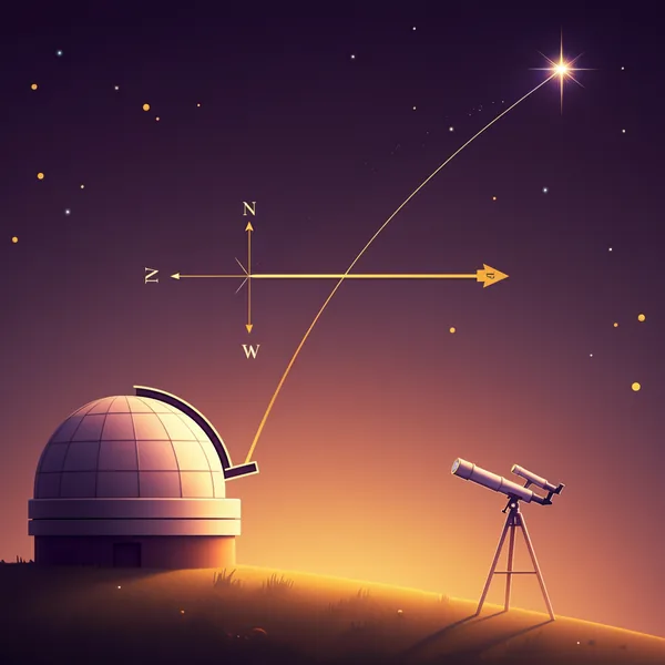
⬆️ Altitude (Elevation Angle)
The angle from the horizon (0°) up to the zenith (90°). The closer a star is to overhead, the closer to 90°.
| Altitude | Meaning |
|---|---|
| 0° | On the horizon (just rising or setting) |
| 30° | Low (typical of late afternoon sun) |
| 60° | Quite high |
| 90° | Zenith (straight up) |
| Negative | Below horizon (not visible) |
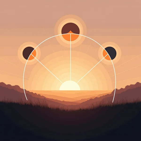
Sun's altitude varies by season — example, New York (latitude 40.71°)
| Date | Solar noon altitude |
|---|---|
| Winter solstice (Dec 22) | ~26° |
| Equinox (Mar/Sep) | ~49° |
| Summer solstice (Jun 22) | ~73° |
That's why your shadow at noon is short in summer (sun overhead) and long in winter (sun low).
➡️ Azimuth
Direction measured clockwise from due north.
| Direction | Azimuth |
|---|---|
| North (N) | 0° (or 360°) |
| East (E) | 90° |
| South (S) | 180° |
| West (W) | 270° |
Sunrise azimuth shifts through the year — example, latitude 40°
| Date | Sunrise azimuth |
|---|---|
| Winter solstice | ~120° (south of east) |
| Equinox | ~90° (due east) |
| Summer solstice | ~60° (north of east) |
For photographers: If you want a "due-east" sunrise, plan for around the equinoxes (March 20, September 22). At winter solstice, the sun rises well south of east — you may not see it from a spot you thought faced east.
🌌 Versus the Equatorial Coordinate System
Star catalogs don't use altitude/azimuth, because those values shift every minute as the Earth rotates. Instead, they use a sky-fixed coordinate system that doesn't depend on observer location or time.
| System | Two coordinates | Property | Use |
|---|---|---|---|
| Horizontal | Altitude, Azimuth | Observer- and time-dependent | Telescope mounts, sunrise direction, satellite tracking |
| Equatorial | Right Ascension (RA), Declination (Dec) | Sky-fixed | Star catalogs, recorded object positions |
| Ecliptic | Ecliptic longitude/latitude | Based on the ecliptic plane | Planetary motion, solar system bodies |
| Galactic | Galactic longitude/latitude | Based on our Galaxy's plane | Extragalactic, globular clusters |
Quick intro to RA & Dec
- Right Ascension (RA, α): Measured along the celestial equator (the Earth's equator projected onto the sky). Units: hours (0–24h, 1h = 15°). The vernal equinox is 0h.
- Declination (Dec, δ): Measured north (+) or south (−) of the celestial equator. Same range as latitude: −90° to +90°.
A given star always has the same RA and Dec (changing only over centuries due to precession), but its altitude and azimuth at your location change every second.
🧮 Equatorial → Horizontal Conversion
If you know a star's RA/Dec and your observer's lat + UTC time, you can compute altitude/azimuth.
sin(altitude) = sin(δ)·sin(φ) + cos(δ)·cos(φ)·cos(H)

cos(azimuth) = ( sin(δ) − sin(altitude)·sin(φ) ) / ( cos(altitude)·cos(φ) )
- φ = observer's latitude (WGS84)
- δ = star's declination
- H = hour angle = local sidereal time (LST) − right ascension
You don't have to do this by hand: apps and websites compute it instantly. The formula is for understanding why the math works. The key takeaway is the observer's latitude is plugged in — so knowing your lat/lng is the starting point.
🌅 Real-World Uses
The horizontal coordinate system isn't just for astronomers. Practical applications are everywhere.
| Field | Use case |
|---|---|
| Solar panels | Solar altitude/azimuth → panel angle (south-facing in Northern Hemisphere, tilted at ~latitude) |
| Architecture & urban planning | Shadow analysis, daylight studies, solar access rights |
| Photography & video | Golden hour timing, exact sunrise/sunset direction (essential for landscape photographers) |
| Stargazing | Altitude-azimuth (Alt-Az) telescope mounts, observatory setup |
| Satellite tracking | GPS / comms ground antennas, ISS visible-pass prediction |
| Maritime / aviation navigation | Celestial navigation with a sextant — an emergency backup even in the GPS era |
| Drone cinematography | Anticipating sun position to avoid lens flare or harsh shadows |
🛠 Recommended Tools (Free)
| Tool | Use | Form |
|---|---|---|
| Stellarium | Most popular planetarium / sky simulator | Desktop + Web |
| TheSkyLive.com | Real-time positions of stars, planets, ISS | Web |
| SunCalc.org | Sunrise/sunset azimuth visualization | Web (over a map) |
| Heavens-above.com | Satellite visible-pass predictor | Web |
| Star Walk 2 | AR identification of stars and planets | iOS · Android |
| Sky Guide | AR astronomy (iOS only) | App Store |
| Stellarium Plus | Mobile version of desktop Stellarium | iOS · Android |
🌐 Relation to WGS84 Coordinates
- WGS84: A point on Earth's surface — latitude/longitude (see the WGS84 guide)
- Horizontal coordinates: A point in the sky as seen from that ground point — altitude/azimuth
The two systems combine orthogonally:
- Determine your WGS84 position (FindLatLng gives you lat/lng to 6 decimals)
- Add the UTC time and a star catalog's RA/Dec
- Apply the conversion formula → horizontal coordinates (where that star is now in your sky)
You need location (WGS84) + time to know how the celestial sphere is rolled over your head.
💬 FAQ
Q. Why is azimuth measured from north? Modern astronomy and navigation standardized on north-as-zero, clockwise. Older astronomy texts sometimes measured from south, but GPS, aviation, marine, and surveying all agree on north-zero today.
Q. Is "altitude" in astronomy the same as in aviation? No — different things. Astronomy altitude is an angle in degrees from the horizon. Aviation altitude is height above sea level in meters or feet. To avoid confusion, astronomers often say "elevation angle".
Q. How fast do stars move across the sky? Earth rotates 360° in 24 hours, so stars move 15° per hour, or 1° every 4 minutes. That's why long-exposure star photos show streaks. Stars near the celestial equator appear to move fastest; stars near the celestial poles (Polaris, +89° declination) barely move at all.
Q. How can I find the exact sunrise direction for a date? Use SunCalc.org — enter your coordinates and a date, and it draws the sunrise/sunset arrows on a map. Essential for landscape photographers planning shoots.
Q. Can I see the ISS from my location? Yes — best around dawn or dusk. Plug your lat/lng into Heavens-above for pass predictions: time, azimuth, peak altitude. The ISS crosses the sky in about 90 seconds, brighter than any star.
📝 Wrap-Up
- Horizontal coordinate system = observer-relative sky coordinates (altitude + azimuth)
- Equatorial system = sky-fixed coordinates (RA + Dec, the star-catalog standard)
- Conversion needs observer's latitude (WGS84) + time — your ground coordinates are the starting point
- Real-world applications: sunrise/sunset photography, solar panels, stargazing, satellite tracking
- A given star has fixed RA/Dec but changing altitude/azimuth — that's why telescopes need motorized tracking
You need your WGS84 lat/lng before you can compute any sky angle. FindLatLng — Lat/Lng Finder →
📚 References & Further Reading
- Wikipedia — Horizontal coordinate system
- Wikipedia — Equatorial coordinate system
- USNO (US Naval Observatory) — Sun & moon position
- SunCalc.org — sunrise/sunset azimuth visualization
- Stellarium — free planetarium software
- Heavens-Above — satellite pass predictions
- IAU SOFA — astronomy reference algorithms
- Related — WGS84 coordinate guide